| Loop: | 9 - Huia Ridge Track | |
| Region: | Piha | |
| Access Point: | Piha Road | |
| Coordinates: | -36.96829 174.51507 | |
Track # | Track Name | Distance (km) |
68 | Huia Ridge Track | 6 |
68 | return Huia Ridge Track | 6 |
Map Distance Measured Distance | 12.0 12.3 |
Completed: Solo on 5 JAN 2012
68. Huia Ridge Track
keywords:
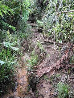
Mostly unrunnable, technical, knee and head high vegetation, roots, hands required, mud/dirt, slippery, single-track, mostly well-marked, steep slope, bush-covered.
comments:
This long out and back track is mostly unrunnable due to the highly uneven and root ridden surface, the steep slope and the mud. The only opportunity to stretch the legs came on a 300 m section of boardwalk. However, the 3 km section to Piha Rd from the Nugget Track junction is pure pleasure and erases the frustrations of the 9 km that went before. Would recommend this section on its own as a test of downhill nimbleness. Overall this track is an exercise in foot/eye coordination and quadricep strength, and suitable as a walk rather than a run. |
| Topo Map (click to enlarge) |
 |
| Elevation Profile (click to enlarge) |
View 9 Huia Ridge Track in a larger map


No comments:
Post a Comment