|
|
|
 |
| Anawhata Beach |
| Loop: | 21 - Anawhata Beach Track and Hettig Track | |
| Region: | Anawhata | |
| Access Point: | Anawhata Road | |
| Coordinates: | -36.92389 174.45852 (Anawhata Beach Track) | |
| -36.92558 174.49526 (Hettig Track) | ||
Track # | Track Name | Distance (km) |
115 | Anawhata Beach Track | 0.7 |
115 | return Anawhata Beach Track | 0.7 |
120 | Hettig Track | 0.5 |
120 | return Hettig Track | 0.5 |
Map Distance Measured Distance | 2.4 2.1 |
Completed: Solo on 27 JAN 2012
120. Hettig Track
keywords:
Runnable (only just), technical, roots, dirt/mud/clay surface, slippery, hands required, single-track, overgrown but well-marked, steep slope, stairs (few), bush covered, view (Marawhara Stream)
comments:
Hettig Track is a short, steep and slippery, and only just runnable, descent to Marawhara Stream and would be pointless as a standalone run. Top Section
115. Anawhata Beach Track
keywords:
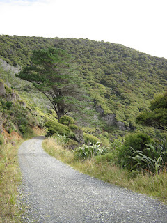
Runnable, non-technical, gravel/dirt surface, medium width, well-marked, steep slope, exposed and bush covered, view (Anawhata Beach).
comments:
Quite a challenging run up because of the steep slope, but the amazing views are worth the return effort. Short and sharp run, of no use stand alone but rather to provide access to Anawhata Beach. |
| Topo Map (click to enlarge) |
 |
| Elevation Profile - Anawhata Beach Track |
 |
| Elevation Profile - Hettig Track |
View 21 Anawhata Beach Track and Hettig Track in a larger map
|
|
| Line 1 Col 1 | Line 1 Col 2 |


No comments:
Post a Comment