|
|
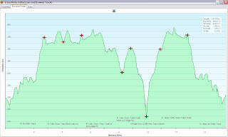
| Loop: | 6 - Ian Wells, Cutty Grass, Browne Tracks | |
| Region: | Piha | |
| Access Point: | Piha Road | |
| Coordinates: | -36.93671 174.55652 | |
Track # | Track Name | Distance (km) |
- | Road | 0.7 |
81 | Ian Wells Track | 2.4 |
41 | Cutty Grass Track North | 1.3 |
41 | return Cutty Grass Track North | 1.3 |
41 | Cutty Grass Track South | 2.5 |
41 | return Cutty Grass Track South | 0.7 |
5 | Ridge Rd Track South | 0.8 |
22 | Browne Track | 0.5 |
22 | return Browne Track | 0.5 |
5 | return Ridge Rd Track South | 0.8 |
41 | return Cutty Grass Track South | 1.8 |
81 | return Ian Wells Track | 2.4 |
- | Road | 0.7 |
Map Distance Measured Distance | 16.4 15.4 |
Completed: Accompanied on 22 OCT 2011
22. Browne Track
keywords:
non-runnable, knee and head-high foliage, dirt, single-track, not well-marked (not maintained), steep slope, bush-covered, view (Anawhata River)
non-runnable, knee and head-high foliage, dirt, single-track, not well-marked (not maintained), steep slope, bush-covered, view (Anawhata River)
comments:
The youthfulness of the entrance sign did not correlate at all with the maintenance of this track. Reduced to walking the entire length as the track was not clear in places. Got more cuts and scratches on this track than on Cutty Grass Track. Involved a steep descent to a river.
41. Cutty Grass TrackThe youthfulness of the entrance sign did not correlate at all with the maintenance of this track. Reduced to walking the entire length as the track was not clear in places. Got more cuts and scratches on this track than on Cutty Grass Track. Involved a steep descent to a river.
keywords:
Runnable, non-technical, rocks, dirt, wide, well-marked, gentle slope, not bush-covered, view (brief glimpse of the vastness of the Waitakeres)
comments:
Despite its name, there was thankfully no Cutty Grass. Track was a wide 4WD maintenance track for the power lines that run alongside. Nice easy slope with a few rocky obstacles.
Despite its name, there was thankfully no Cutty Grass. Track was a wide 4WD maintenance track for the power lines that run alongside. Nice easy slope with a few rocky obstacles.
Top Section
81. Ian Wells Track (formerly Upper Nihotupu Track)keywords:
Runnable, technical, rocks, roots, river crossings, slippery, mud/dirt, single-track, well-marked, medium slope, bush-covered, view (river)
Runnable, technical, rocks, roots, river crossings, slippery, mud/dirt, single-track, well-marked, medium slope, bush-covered, view (river)
comments:
This exciting single-track had a good balance of technical and non-technical sections. Some parts were muddy and flooded, and the medium incline allowed for constant running. A charming riverside spot about half-way.
This exciting single-track had a good balance of technical and non-technical sections. Some parts were muddy and flooded, and the medium incline allowed for constant running. A charming riverside spot about half-way.
 | ||
Topo Map (click to enlarge)
|
 |
| Browne Track |
|
|


That looks pretty great. Bet its was fantastic
ReplyDelete