Tuesday, 25 October 2011

7 - McElwain, Quarry, Mckenzie, Piha Valley and Centennial North Tracks (Anawhata)

McElwain Lookout Track

Centennial Track (north)
                                                                                                                        
Loop:

7 - McElwain, Quarry, McKenzie, Piha Valley and Centennial North Tracks
Region: Anawhata
Access Point: Anawahta Rd
Coordinates: -36.93712 174.51381
Track #
Track Name
Distance (km)
114
McElwain Lookout Track
1
104
Quarry Track
1.1
102
McKenzie Track
1.1
101
Piha Valley Track
1
101
return Piha Valley Track
2.2
100
Centennial Track
1.95
Map Distance
Measured Distance
8.35
8.35
                                                                                                                        
Completed: Accompanied on 24 OCT 2011

114. McElwain Lookout Track
keywords:
Runnable, non-technical, rocks, gutters, head high foliages, rock/dirt, narrow, well marked, not bush-covered, easy to medium slope, view (Stunning view of the Waitakeres to Piha).
comments:
Short walking loop track to a lookout tower (354 m) with amazing views.

104. Quarry Track
keywords:
Runnable, technical, rocks, roots, dirt/mud, narrow, single-track, well marked, bush-covered, medium slope.
comments:
Short track with some highly technical, muddy and slippery sections.

102. McKenzieTrack
keywords:
Runnable, technical, rocks, roots, river crossing, hands required, dirt/mud, clay, slippery, single/track, well-marked, bush-covered, steep slope, stairs (few).
comments:
Very steep descent to Piha Valley. Highly technical and slippery in places. Opens up into a wider track in a section of beautiful open bush. Rewarded at the bottom with a river crossing.

101. Piha Valley Track
keywords:
Runnable, non-technical, some roots, rocks and mud, dirt/mud/gravel, wide, well-marked, flat slope (Glenesk Rd to McKenzie Track), steep slope (McKenzie to Centennial Tracks), stairs (lots), view (Piha Stream and Piha Gorge).
comments:
A flat easy run combined with a sharp, steep stair climb. Views of the river and gorge the entire way to numb the boredom or pain.
                                                                                                                        
Top Section
100. Centennial Track (north)
keywords:
Runnable, non-technical, some rocks and roots, river-crossing, mud/dirt, single track, well-marked, bush-covered, medium slope, view (Piha Stream and Waitakeres). 
comments:
Feels like a long track with a very consistent medium gradient just above comfortable. Some small obstacles along the way. Overall non-technical but some how an enviable sense of achievement evolves whilst stopping to enjoy the view from near the top.
                                                                                                                        

Topo map (click to enlarge)


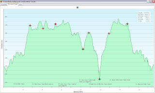
Elevation Profile (click to enlarge)

View 7 McElwain, Quarry, Mckenzie, Piha Valley and Centennial North Tracks in a larger map
Google maps is having issues, hopefully it will be resolved and this map will show correctly!


Quarry Track

Quarry Track


McKenzie Track

McKenzie Track


Piha Valley Track

Piha Valley Track

Centennial Track (north)
View from McElwain Lookout
Piha River from Centennial Track (north)

Saturday, 22 October 2011

6 - Ian Wells, Cutty Grass and Browne Tracks (Piha)

Ian Wells Track
Cutty Grass Track
                                                                                                                        
Loop:6 - Ian Wells, Cutty Grass, Browne Tracks
Region:Piha
Access Point:Piha Road
Coordinates:-36.93671 174.55652
Track #
Track Name
Distance (km)
-
Road
0.7
81
Ian Wells Track
2.4
41
Cutty Grass Track North
1.3
41
return Cutty Grass Track North
1.3
41
Cutty Grass Track South
2.5
41
return Cutty Grass Track South
0.7
5
Ridge Rd Track South
0.8
22
Browne Track
0.5
22
return Browne Track
0.5
5
return Ridge Rd Track South
0.8
41
return Cutty Grass Track South
1.8
81
return Ian Wells Track
2.4
-
Road
0.7
Map Distance
Measured Distance
16.4
15.4 
                                                                                                                        
Completed: Accompanied on 22 OCT 2011

22. Browne Track
keywords:
non-runnable, knee and head-high foliage, dirt, single-track, not well-marked (not maintained), steep slope, bush-covered, view (Anawhata River)
comments:
The youthfulness of the entrance sign did not correlate at all with the maintenance of this track. Reduced to walking the entire length as the track was not clear in places. Got more cuts and scratches on this track than on Cutty Grass Track. Involved a steep descent to a river.

41. Cutty Grass Track
keywords:
Runnable, non-technical, rocks, dirt, wide, well-marked, gentle slope, not bush-covered, view (brief glimpse of the vastness of the Waitakeres)
comments:
Despite its name, there was thankfully no Cutty Grass. Track was a wide 4WD maintenance track for the power lines that run alongside. Nice easy slope with a few rocky obstacles.
                                                                                                                        
Top Section
81. Ian Wells Track (formerly Upper Nihotupu Track)
keywords:
Runnable, technical, rocks, roots, river crossings, slippery, mud/dirt, single-track, well-marked, medium slope, bush-covered, view (river)
comments:
This exciting single-track had a good balance of technical and non-technical sections. Some parts were muddy and flooded, and the medium incline allowed for constant running. A charming riverside spot about half-way.
                                                                                                                        
Topo Map (click to enlarge)

Elevation Profile (click to enlarge)

Browne Track
Ian Wells Track
Cutty Grass Track

Wednesday, 19 October 2011

5 - Upper Huia Dam Track (Huia)


Loop: 5 - Upper Huia Dam Track
Region: Huia
Access Point: Piha Road
Coordinates: -36.94392 174.53631
Track #
Track Name
Distance (km)
133
Upper Huia Dam Track
4
133
return Upper Huia Dam Track
4
Map Distance
Measured Distance
8
7.8
                                                                                                                        
Completed: Solo on 19 OCT 2011

133. Upper Huia Dam Track
keywords:
Partially-runnable, technical, rocks, roots (lots), river crossings, head high foliage, mud, slippery, narrow, well-marked, easy slope, bush covered, view (dam)
comments:
The first 1 km is frustratingly un-runnable with roots crossing the track at every step. A highly technical single-track with a very gradual slope to Upper Huia Dam. Enjoyable, if you can make it past the first 1 km. Recommended as a dry weather track as is muddy, slippery and full of small lakes. Watch the supple jack overhead, it will take your eye out.

Topo Map. Click to enlarge.

Elevation Profile. Recalibration in the middle, still off at the end...but you get the picture.
Gentle Slope, Click to enlarge.


Tuesday, 18 October 2011

3 - Odlin Timber Track (Karekare)


Loop: 3 - Odlin Timber Track
Region: Karekare
Access Point: Lone Kauri Road
Coordinates: -36.99660 174.49940
Track #
Track Name
Distance (km)
80
Odlin Timber Track
2.8
80
return Odlin Timber Track
2.8
Map Distance
Measured Distance
5.6
5.6
                                                                                                                        
Completed: Solo on 18 OCT 2011

80. Odlin Timber Track
keywords:
mostly runnable, technical, hands required, rocks, roots, river crossings, mud, clay, slippery, wide, well-marked, steep slope, stairs, bush covered
comments:
Embracing this run in a downpour resulted in a slippery experience! Some sections were not runnable in the rain with a number of washed out clay v-channels with foot steps dug into the clay. Track was either ascending or descending, there were no flat sections on this run! A very exciting, highly technical single-track.


Topo map. Click to enlarge.
Elevation Profile with a recalibration in the middle, data still shows drift but you get the idea. 
Click to enlarge.


View 3 - Odlin Timber Track in a larger map


Monday, 17 October 2011

1 - Goldie Bush (Bethells - Te Henga)

Te-Henga-Goldie Bush Walkway (east)
Mokoroa Falls Track


Loop: 1 - Goldie Bush
Region: Bethells - Te Henga
Access Point: Horseman Road
Coordinates: -36.84638 174.47434
Track #
Track Name
Distance (km)
1
Mokoroa Falls Track
1.5
?
Goldie Bush Walk (Mokoroa Stream Track)
2.5
142
Te-Henga-Goldie Bush Walkway (east)
1.3
142
return Te-Henga-Goldie Bush Walkway (east)
3.9
Map Distance
9.2
Measured Distance
8.2

                                                                                                                        
Completed: Solo on 15 OCT 2011

1. Mokoroa Falls Track
keywords:
 runnablenon technical, gravel, wide, very well marked,  medium slope,  bush covered,  
view (Mokoroa Falls)
comments:
Very placid short run down to a view of an AMAZING waterfall

?. Goldie Bush Walk (Mokoroa Stream Track)
keywords:
 non-runnable, highly technical,  roots, rocks, mud, slippery, hands required, river crossings, knee and head high foliage, narrow, mostly well marked, bush covered, river bank, view (Mokoroa River)
comments:
Nice terrain for a tramp, very challenging to run. A number (lost count) of  river crossings over slippery rocks. Some climbing involved, recommend gaiters and eye protection for overgrown foliage.

142. Te-Henga-Goldie Bush Walkway (east) (section from Mokoroa River to Constable Road)
keywords:
runnable, non technical,  gravel, wide, very well marked, medium slope, stairs (lots), bush covered
comments:
Placid gravel run, with a huge number of stairs to help with the steep ascent in places
                                                                                                                        
Top Section
142. return Te-Henga-Goldie Bush Walkway (east) (section from Mokoroa River to Mokoroa Falls Track)
keywords: 
runnable, technical, roots, mud, wide, well marked, medium slope, stairs (lots), bush covered, view (swing bridge)
comments:
Stairs to help with the steep ascent from the river valley. Mud the entire way in October, and of a slope just steep enough to slip with every step. Good run, the best section of the four.


Topo Map (click to enlarge)
Click to enlarge

Elevation Profile - Click to enlarge


View 1 - Bethells - Te Henga - Goldie Bush in a larger map

Mokoroa Falls 
Mokoroa Stream Track


Te-Henga-Goldie Bush Walkway (east) 


Saturday, 15 October 2011

Preparation - The Gear

The gear that I will be taking with me on each run is shown below. It looks quite excessive all laid out. For alpine runs like The Goat, there are minimum gear requirements which pretty much includes all of the below, minus all the fancy electronics and navigation equipment. What I am not taking with me on these runs that is required on the alpine runs are thermal bottoms and a small first aid kit. 

Find below a list of what I will be carrying with me. Train as one intends to fight! Although I do enjoy minimalist running with nothing but a car key, the length of the these runs and the remoteness of some of the locations does require a degree of being sensible and being prepared for any scenario.

And so it begins!

See below for a detailed list of what is in the photo:

Be Prepared - My Gear
1. Camelbak Mule
2. Macpac 3 L bladder
3. Canon Ixus 2.0 old school digital camera
4. Garmin eTrex 30 GPS receiver
5. Nokia 5230 mobile phone
6. Compass
7. Pencil
8. Pen
9. Waterproof notebook
10. Emergency blanket
11. Whistle
12. x2 Leppin energy gels
13. Waitakere Ranges Park Map in waterproof map holder
14. Woollen gloves
15. Lightweight North Face rain jacket
16. Merino thermal top
17. Woollen hat
18. x3 small waterproofing devices (aka. plastic bags)
19. x1 pack liner (aka. larger plastic bag)

On my person I will be wearing:
1. All of the above
2. Car key
3. Sun glasses / hat if conditions demand so
4. A covering of sunscreen
5. ex Auckland Marathon Adidas Dryfit running top
6. Well used Active Intent (Warehouse Brand) running shorts
7. Footwear - Asics Trabuco Trail shoes
8. Baby G watch
9. Great deal of enthusiasm =)

Friday, 14 October 2011

Preparation - Setting the Loops

What I thought would be a straightforward task, escalated rapidly into a large beast.

The task was to incorporate all the walking and tramping tracks in the Waitakere Ranges into sets of runnable loops while trying to reduce the amount of repetition of the sections. There were a few things to consider, such as the distance of the loops, access points, parking, and terrain. Towards the end, well actually right near the beginning, I discarded any consideration of terrain - you get what you are going to get, and at some point you will have to run it so harden up! Although I am frightfully reminded of some sections of the Waitakeres that I have run and being very thankful at the time to be descending them. Yup, this is going to be a lung busting challenge.

So over the course of the last couple of weeks? I have been pouring over my Terralink Hunua and Waitakere Ranges Recreation Area map (edition 2 2005, now out of print) and piecing together trails into loops. I have been using the list of trails on the ARC website and utilising the track index this chap  fathmandu has provided. He had a similar endeavour although we are in slightly different leagues with him being an older, 120 kg walker.

Note: That I have used the distances indicated on the map described. In cases where distances were not stipulated on the map, I supplemented the data with that provided on the ARC website although it was noticed that at times there were discrepancies between the two data sources. I even considered asking ARC if they would pay me to update their track distances.... still might....

The result:
Total Distance of Waitakere Trails: 269 km
Total Number of labelled Waitakere Trails: 145 trails


What I have incorporated into loops: 247 km / 116 trails
Discarded due to being standalone short trails: 22 km / 29 trails
Percentage distance incorporated into loops:  92 %


Number of loops to Run: 40 loop trails
Total distance to be covered: 380 km


Mean distance of loop trail: 9.5 km
Maximum: 17.6 km (Te-Henga-Goldie Bush Walkway (west) return)
Minimum: 1.4 km (Anawhata Beach Track return)
Median: 9.8 km

The realisations:
* That this is probably going to take me more than just summer to knock off;
* It is going to cost me a lot of petrol and travel time;
* That I will be running 55 % more distance than required due repetition of sections:
* That I really want to get out there and start running! - a GPS is in the mail!

Saturday, 1 October 2011

Introduction

Welcome.

I have a mission.

My mission is to run all of the trails in the Waitakere Ranges, in West Auckland, New Zealand. I've heard there is 250 km of trail running goodness to be had, and I intend to have it all! And in true scientific style, I intend to document it.

This idea was spawned after an amazing trail run in the Waitakeres with two good running friends while training for the 2011 T42 off-road marathon. It was rekindled while dozing in bed one night when I realised I would have a bit of spare time this summer to knock off this dream. I am currently training for 2011 The Goat, a 21.1 km alpine adventure run around Mt Ruapehu in National Park, and I intend to do more training in the Waitakere Ranges, but where? Searching for a comprehensive listing of the nature of the trails available, I found it lacking somewhat, thus my inspiration was found, perhaps I could contribute something here?

I initially started with the intention to photograph all of the trail signs that I encountered en-route but my scientific background led me down the obsessive path of data collection and I wondered what further data I could acquire?  This began a frantic searching for some sort of GPS device that does altitude and heart rates with all the bells, and that can generate pretty graphs. That purchase is still a research work in progress. I'm hoping I can test drive (aka borrow) my friends $500 piece of Garmin wrist technology, but we will see, it would be more of a long term lend, this adventure will be more than just a week long comittment!

So what follows is my adventure: to run (and at times probably walk) all of the trails in the Waitakere Ranges. I hope you find something useful in the posts that will follow.